Database for API
Overview
The database for API contains COG(Cloud Optimized GeoTIFF) and STAC(Spatio Temporal Asset Catalog). COG is one of the TIFF format which can be get through http range request depend on user’s area of interest, resolution. STAC is catalog information in hierarchical json format to access COG. The Database’s specification which is consist of COG and STAC is determined to accomplish effective data distribution by API for various earth obsevation satellite’s image which can be projected in map.
Note
Attention! Land Cover Class data is only in 2019, GCOM-C SGLI data (RGB) is only in Des, 2021, Forest Non Forest data is from 2017-2020, JASMES japan area’s data is from 2020 to 2022/9.
Datasets
The database’s all COG/STAC datasets is visualized and cataloged in the site below. In this site, users can view and check the visualized data without any preparation.
Structure
COG/STAC structure is designed to effectively deliver the earth observation data depend on user query.
COG (Cloud Optimized GeoTIFF)
If you would like to know general information of COG, please check the official site below.
In the database we defined COG levels so that the database can store a lot kind of resolution and area levels. Table 1,2 shows the database’s COG levels definition. Each COG has internal IMG levels up to two. Figure 1 shows relation of COG Level and IMG Level.
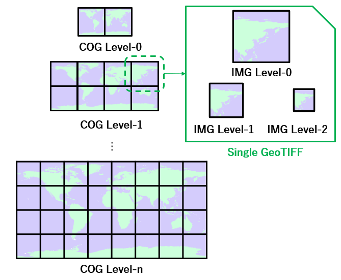
Figure 1 Relation between COG level and IMG level
The IMG level which each COG will have will depend on the selected maximum ppu (Pixels Per Unit(1degree(EPSG4326) or 32786m(EPSG3995/EPSG3031))). Collection’s maximum ppu will be selected from the table above the original ppu. All images below the maximum resolution are generated. For example, if original data’s ppu is 7, the database’s maximum ppu is 10 and 5,2.5,1.25 ppu image is created as COG. Thus, COG Level 0 (internal IMG level number is three) and COG Level 1 (internal IMG level number is one) will be generated.
COG level |
Image Size (degree) |
IMG level |
Image Size (pixels) |
PPU |
|---|---|---|---|---|
level 0 |
180/180 deg |
level 2 |
225/225 pixels |
1.25 |
level 1 |
450/450 pixels |
2.5 |
||
level 0 |
900/900 pixels |
5 |
||
level 1 |
90/90 deg |
level 2 |
900/900 pixels |
10 |
level 1 |
1800/1800 pixels |
20 |
||
level 0 |
3600/3600 pixels |
40 |
||
level 2 |
10/10 deg |
level 2 |
900/900 pixels |
90 |
level 1 |
1800/1800 pixels |
180 |
||
level 0 |
3600/3600 pixels |
360 |
||
level 3 |
1/1 deg |
level 2 |
900/900 pixels |
900 |
level 1 |
1800/1800 pixels |
1800 |
||
level 0 |
3600/3600 pixels |
3600 |
||
level 4 |
0.1/0.1 deg |
level 2 |
900/900 pixels |
9000 |
level 1 |
1800/1800 pixels |
18000 |
||
level 0 |
3600/3600 pixels |
36000 |
COG level |
Image Size (m) |
IMG level |
Image Size (pixels) |
PPU |
|---|---|---|---|---|
level 0 |
2^24/2^24 m |
level 2 |
512/512 pixels |
1 |
level 1 |
1024/1024 pixels |
2 |
||
level 0 |
2048/2048 pixels |
4 |
||
level 1 |
2^21/2^21 m |
level 2 |
512/512 pixels |
8 |
level 1 |
1024/1024 pixels |
16 |
||
level 0 |
2048/2048 pixels |
32 |
||
level 2 |
2^18/2^18 m |
level 2 |
512/512 pixels |
64 |
level 1 |
1024/1024 pixels |
128 |
||
level 0 |
2048/2048 pixels |
256 |
STAC (Spatio Temporal Asset Catalog)
If you would like to know general information of STAC, please check the official site below.
The database’s STAC mainly has five kind of layers such as collection, date, cog level, longitude and latitude. Only date layers may have multiple STAC layers depend on temporal resolution. Table 3 shows the database’s STAC levels definition.
layer name |
number of layers |
stac type |
description |
|---|---|---|---|
collection |
1 |
collection |
Collection’s name. Organization name, Satellite, Sensor, Original Product’s name, version, area are concatenated as the name. |
date |
from 1 to 3 |
catalog |
The value represents observation date. |
cog level |
1 |
catalog |
The value represents COG level. |
longitude |
1 |
catalog |
COG’s minimum longitude and maximum longitude are used as the name. |
latitude |
1 |
item |
COG’s minimum latitude and maximum latitude are used as the name. |