Datasets
The datasets include JAXA's public Earth observation datasets and other agencies' public datasets converted to COG (Cloud Optimized GeoTIFF). More than 100 datasets are available. They cover a part of the Earth observation data published by JAXA, and more will be added in due course.
Land Surface Data
These datasets are observed by the ALOS series of satellites (the Advanced Land Observing Satellite-2 "Daichi-2" (ALOS-2) and the Advanced Land Observing Satellite "Daichi" (ALOS) ). Data with a spatial resolution of approximately 10 to 30 m are available.
Precipitation
The Global Satellite Mapping of Precipitation (GSMaP) datasets are available, which shows the global precipitation, by using data from the GPM core satellite, meteorological satellites around the world and so on. It contains data (monthly, half-monthly and daily averages) for over 25 years since March 2000.
Land Surface Temperature
Land surface temperature (LST) observed by the Global Change Observation Mission - Climate "SHIKISAI" (GCOM-C). When there are clouds, observations are not possible and data is missing. JAXA Earth API publishes data with a spatial resolution of about 5km. Daytime data was observed around 10:30am local time in each area, and nighttime data was observed around 10:30pm local time in each area.
Sea Surface Temperature (by GCOM-C)
Sea surface temperature (SST) observed by the Global Change Observation Mission - Climate "SHIKISAI" (GCOM-C). It is characterized by its ability to observe coastal areas with a spatial resolution of approximately 250m. When there are clouds, observations are not possible and data is missing. JAXA Earth API publishes global data with a spatial resolution of approximately 250m. Daytime data was observed around 10:30am local time in each area, and nighttime data was observed around 10:30pm local time in each area.
Sea Surface Temperature (by GCOM-W)
Sea surface temperature (SST) observed by the Global Change Observation Mission - Water "SHIZUKU" (GCOM-W). It can be observed even when there are clouds. The spatial resolution is lower than that of GCOM-C, and data is missing near the coast because it cannot observe. Daytime data was observed around 1:30pm local time in each area, and nighttime data was observed around 1:30am local time in each area. This data uses a 5-day moving average to reduce missing values due to outside the observation range, etc.
Chlorophyll-a Concentration
Chlorophyll-a concentration (CHLA) observed by the Global Change Observation Mission - Climate "SHIKISAI" (GCOM-C). It shows the distribution of phytoplankton. It is characterized by its ability to observe up to the coast with a spatial resolution of about 250m. When there are clouds, observations are not possible and data is missing. JAXA Earth API publishes global data with a spatial resolution of about 250m.
Normalized Difference Vegetation Index
Normalized difference vegetation index (NDVI) observed by the Global Change Observation Mission - Climate "SHIKISAI" (GCOM-C). It shows the distribution and health of plants (leaves). When there are clouds, observations are not possible and data is missing. JAXA Earth API publishes data with a spatial resolution of about 5km.
Soil Moisture Content
Soil moisture content (SMC) observed by the Global Change Observation Mission - Water "SHIZUKU" (GCOM-W).
Sea Ice Concentration
Sea Ice Concentration (IC) observed by the Global Change Observation Mission - Water "SHIZUKU" (GCOM-W).
By using the AI Dataset Catalog in Markdown format, an AI chat assistant can select and explain the data for you. Try attaching the AI Dataset Catalog to an AI chat and asking your questions.
APIs
By using the API modules, you can retrieve data for any area, time, and dataset. Both Python and JavaScript are supported.
By using the AI documentation in Markdown format, an AI chat assistant can explain how to use the API and create sample code. Try attaching the AI documentation to an AI chat and asking your questions. Attaching the AI Dataset Catalog above to the AI chat as well also enables the selection of datasets.
How JAXA Earth API works
In JAXA Earth API, the server side provides static data distribution in COG/STAC format, and the Python/JavaScript modules running on the client side dynamically retrieve the required data. This achieves data distribution with a serverless configuration that requires no dynamic processing on the server side.
COG (Cloud Optimized GeoTIFF)
JAXA Earth API uses a file format called COG, which is suitable for online satellite data distribution. This makes it possible to efficiently retrieve only the data for the required area and zoom level. COG files can also be downloaded as they are and used with GIS analysis tools and other software.
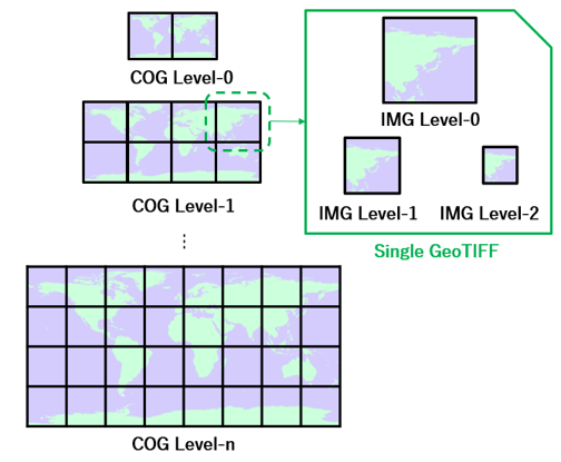
STAC (SpatioTemporal Asset Catalogs)
So that the multiple COG files contained in a dataset can be searched mechanically, all COG files are cataloged in JSON files of a format called STAC. As it is an open standard, it can also be used by other STAC-compliant systems.
Apps
These are use cases of JAXA Earth API. Everything from AI integration to use in QGIS and web app development is possible.
See the Pen CesiumJS example by JAXA Earth API (@jaxa-earth) on CodePen.
An example of using the JavaScript API on CodePenLicense
The JAXA Earth API currently has no restrictions on user registration, API key issuance, or the number of times the API can be used. Under the conditions below, the API modules can be used free of charge in various development environments, and the open-source modules can also be modified.
For the license of each dataset, please check the license information specified in each data's STAC. Data to which the Terms of Use of Research Data apply may also be used commercially.
However, the API and data are provided on an "AS IS" basis, and the specifications may change or publication may cease without notice in the future. While every effort is made to keep the content of the API and data as accurate as possible, we do not guarantee their accuracy, completeness, reliability, operation, or the like. JAXA assumes no responsibility whatsoever for any dispute or damage arising from the use of the API and data, regardless of the reason. Use of the API and data in any way that is socially inappropriate, such as contrary to public order and morals, is prohibited.
When publishing results created using this API in papers, on websites, or the like, or when releasing software that incorporates the API modules, please clearly state so in the text. Examples: "This data was obtained using JAXA Earth API", "Image: Created using JAXA Earth API", "The JAXA Earth API for Python module has been used."
These license terms are subject to change without notice. If you have any questions, please contact us.
Information
- 2026/05/22
- JAXA Earth API for JavaScript Version 2.0.1 has been released.
- 2026/05/18
- JAXA Earth API for Python Version 0.1.6 has been released.
- 2026/05/15
- Awarded "the Remote Sensing Technology Award 2026" by the Remote Sensing Society of Japan.

- 2026/02/18
- JAXA Earth API for JavaScript Version 2.0.0 has been released (Japanese version only). MCP development is now possible in JavaScript as well.
- 2026/01/14
- JAXA Earth API for Python Version 0.1.5 has been released. Development of MCP (Model Context Protocol) for integration with generative AI is now possible.
JAXA Earth Observation Research Center (EORC)
JAXA Earth Observation Research Center (EORC) conducts Earth science research and application research using data acquired by Earth observation satellites. It promotes the development of analysis methods for deriving physical variables meaningful to Earth science, as well as calibration and validation to secure the quality of satellite Earth observation data, and publishes the various satellite Earth observation data that have been developed.
On the other hand, satellite Earth observation data have different specifications depending on the satellite, sensor, and distribution system, and specialized knowledge is required to use the data across these differences. For this reason, we started the development of the data distribution service "JAXA Earth API", which makes it possible to easily use multiple satellite Earth observation datasets held by JAXA from a programming environment (Python, JavaScript) via an API (Application Programming Interface).
Contact
Z-ASIST◎ml.jaxa.jp (Please replace "◎" with an at sign)