Database
Overview
The database for API contains COG (Cloud Optimized GeoTIFF) and STAC (Spatio Temporal Asset Catalog).
- COG is a TIFF format that can be fetched via HTTP range requests depending on the user's area of interest and resolution.
- STAC is catalog information in hierarchical JSON format to access COG.
All COG/STAC datasets are visualized and cataloged at:
https://data.earth.jaxa.jp/en/datasets/
COG (Cloud Optimized GeoTIFF)
For general COG information: https://www.cogeo.org/
The database defines COG levels so that it can store many kinds of resolution and area levels. Each COG has up to two internal IMG levels.
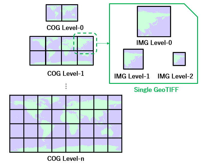
COG levels (EPSG4326)
| COG level | Image Size (degree) | IMG level | Image Size (pixels) | PPU |
|---|---|---|---|---|
| level 0 | 180/180 deg | level 2 | 225/225 pixels | 1.25 |
| level 1 | 450/450 pixels | 2.5 | ||
| level 0 | 900/900 pixels | 5 | ||
| level 1 | 90/90 deg | level 2 | 900/900 pixels | 10 |
| level 1 | 1800/1800 pixels | 20 | ||
| level 0 | 3600/3600 pixels | 40 | ||
| level 2 | 10/10 deg | level 2 | 900/900 pixels | 90 |
| level 1 | 1800/1800 pixels | 180 | ||
| level 0 | 3600/3600 pixels | 360 | ||
| level 3 | 1/1 deg | level 2 | 900/900 pixels | 900 |
| level 1 | 1800/1800 pixels | 1800 | ||
| level 0 | 3600/3600 pixels | 3600 | ||
| level 4 | 0.1/0.1 deg | level 2 | 900/900 pixels | 9000 |
| level 1 | 1800/1800 pixels | 18000 | ||
| level 0 | 3600/3600 pixels | 36000 |
COG levels (EPSG3995/EPSG3031)
| COG level | Image Size (m) | IMG level | Image Size (pixels) | PPU |
|---|---|---|---|---|
| level 0 | 2^24/2^24 m | level 2 | 512/512 pixels | 1 |
| level 1 | 1024/1024 pixels | 2 | ||
| level 0 | 2048/2048 pixels | 4 | ||
| level 1 | 2^21/2^21 m | level 2 | 512/512 pixels | 8 |
| level 1 | 1024/1024 pixels | 16 | ||
| level 0 | 2048/2048 pixels | 32 | ||
| level 2 | 2^18/2^18 m | level 2 | 512/512 pixels | 64 |
| level 1 | 1024/1024 pixels | 128 | ||
| level 0 | 2048/2048 pixels | 256 |
STAC (Spatio Temporal Asset Catalog)
STAC is a hierarchical JSON catalog used to access COG data efficiently.
The STAC COG URL used by this API:
PPU (Pixels Per Unit)
PPU (Pixels Per Unit) represents resolution:
- In EPSG4326: pixels per 1 degree
- In EPSG3995/EPSG3031: pixels per 32786 m
The collection's maximum PPU is selected from the table based on the original data PPU. For example, if the original data's PPU is 7, the database maximum PPU is 10, and images at 5, 2.5, 1.25 PPU are also generated.